Agrotti
Version: 1.0.1
67.76MB
4.1
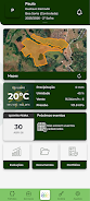
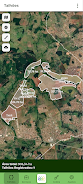



Agrotti is a precision agriculture app built for Agrotti clients that converts georeferenced field data and remote sensing into practical guidance for soil fertility management and plant nutrition. The app helps technicians and rural producers identify spatial variability across fields, prioritize investments, and monitor productivity trends so interventions become more efficient and cost-effective. By combining geostatistics with on‑the‑ground experience, Agrotti delivers objective, data-driven recommendations that aim to boost yields and profitability in Brazilian agribusiness. Users who manage large operations or want to optimize input distribution will find this tool valuable for planning and field decision-making.
⭐ Integrates georeferenced data and remote sensing imagery to map field variability.
⭐ Applies geostatistics to analyze spatial variability and define management zones.
⭐ Converts field measurements into actionable recommendations for soil fertility and plant nutrition.
⭐ Provides monitoring tools to track productivity evolution and evaluate interventions over time.
⭐ Supports technicians and rural producers in prioritizing investments to improve input distribution efficiency.
⭐ Designed to run on compatible Android devices meeting minimum specs: 4GB RAM, octa-core processor, Android 9.0+.
✅ Data-driven recommendations reduce guesswork and improve decision quality with Agrotti.
✅ More efficient allocation of inputs can lead to higher profitability and lower waste.
✅ Objective analysis based on remote sensing and geostatistics increases the precision of recommendations.
✅ Continuous productivity monitoring helps spot problems early and measure the results of corrective actions.
❎ Access is restricted to Agrotti clients, so the app is not available to the general public.
❎ Requires a modern Android device that meets the minimum specifications (4GB RAM, octa-core, Android 9.0+).
❎ The platform’s focus on Brazilian agribusiness means some features and datasets may be region-specific.
Agrotti’s team specializes in soil fertility management and plant nutrition and is guided by three core principles: Technology, Innovation and Objectivity; they combine remote sensing, georeferenced data and extensive experience in spatial variability to deliver precision agriculture services aimed at improving profitability and operational efficiency.