West Highland Way
Version: 1.2.1
30.00MB
4

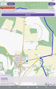
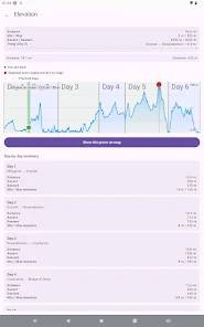


West Highland Way Companion puts the full 154 km West Highland Way route on your phone so you can plan, navigate and record a long-distance walk without depending on mobile signal. The app delivers detailed offline maps, live GPS positioning, simple route tracking and a built-in walking journal that attaches notes and photos to locations. Hikers will appreciate being able to track progress, place journal pins directly on the map and export memories when they have a connection. Whether you’re planning or already on the trail, West Highland Way makes navigation and trip logging straightforward.
⭐ Full offline map of the entire West Highland Way route with live GPS positioning.
⭐ Clear route tracking so you can see your current position and overall progress.
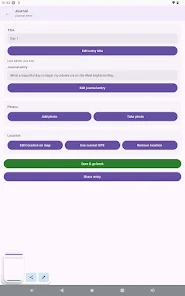
⭐ Built-in walking journal for day-by-day notes with photo attachments tied to locations.
⭐ Journal pins appear on the map so memories can be revisited from their exact spot.
⭐ Exportable journal entries to share your walk or keep a permanent record.
⭐ Designed to work offline in remote Highland environments where mobile signal is unreliable.
✅ Reliable navigation for the West Highland Way that keeps the route visible even without network coverage.
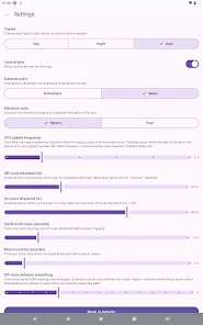
✅ Focused, easy-to-use interface built around walking, tracking and journaling.
✅ Lets you capture photos and notes as you go, creating a chronological travel diary tied to the map.
✅ Lightweight and purposeful tool for planning, following and reviewing a long-distance hike.
❎ Focused specifically on the West Highland Way, so it is not intended as a general mapping app for other routes.
❎ Core functionality depends on your device’s GPS, so accurate positioning requires a compatible, charged device.
❎ The app emphasizes navigation and journaling rather than booking services or third-party trail support features.