
Lịch Thủy triều Việt Nam
Version: 1.0.0
68.00MB
4.3


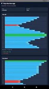
Lịch Thủy triều Việt Nam is a focused tide reference app that lets you look up daily tidal levels for multiple coastal locations across Vietnam. The app displays hourly water level graphs over a 24‑hour period in meters, highlights the day's highest and lowest tides with their corresponding times, and provides both Gregorian date selection and a lunar calendar view. A searchable location list and filters let you choose one, several, or all sites for comparison. Users who need clear, day-by-day tide data will find it practical for planning activities that depend on accurate tide information.
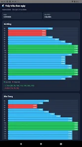
⭐ View hourly water level graphs for each location, showing a full 24-hour profile in meters.
⭐ See the highest and lowest tide levels of the day along with exact times.
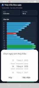
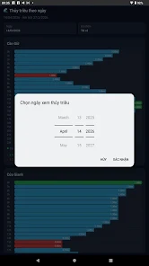
⭐ Select any date using the Gregorian calendar and check the corresponding lunar calendar view.
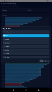
⭐ Filter and choose one, multiple, or all locations with an integrated search box — Lịch Thủy triều Việt Nam makes site selection quick.
⭐ Compare multiple coastal points side by side to assess daily tidal patterns.
✅ Lịch Thủy triều Việt Nam presents clear, meter-based tidal data that’s easy to read at a glance.
✅ Hourly graphs and marked daily highs/lows help users understand short-term tide behavior.
✅ Search and filter tools simplify finding specific locations along the coast.
✅ Combined Gregorian and lunar calendar views provide useful temporal context for each selected date.
❎ The app focuses specifically on tidal heights and daily highs/lows, so users seeking broader marine or weather information may need additional tools.
❎ Data is presented per selected date, which may feel less convenient for those wanting continuous live monitoring without manual date changes.