SEM San Fernando
Version: 17.2
10.00MB
4.2

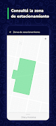
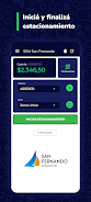
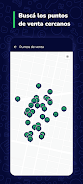
SEM San Fernando is a mobile application designed to connect residents with municipal emergency services, real-time alerts, and community resources. The app centralizes incident reporting, official announcements, and contact directories so users can quickly request assistance, track events, and receive accurate local information from San Fernando authorities.
The SEM San Fernando app provides a concise set of tools to streamline communication between the public and local service teams. Core features include push notifications for urgent events, a geo-aware incident reporter that attaches location data to submissions, and an up-to-date directory of emergency contacts. A built-in newsfeed and bulletin area distributes verified notices from city departments so residents avoid rumor and misinformation.
Designed for straightforward navigation, SEM San Fernando places essential actions on the main screen: report a problem, see active alerts, and call for immediate assistance. The layout minimizes steps needed to file a report by offering photo attachments, short description templates, and preset categories like medical, fire, road hazards, and public safety. Users can save favorite contacts and routes for faster access when time matters.
Interactive maps help people visualize active incidents and service deployments across San Fernando. Each map marker includes status indicators and estimated response times where available. Layers toggle different types of events so users can focus on traffic disruptions, weather advisories, or health-related alerts independently. The mapping tools are useful for planning safe routes during localized incidents and for community volunteers coordinating relief.
Accounts allow residents to tailor notifications by category, radius, and time of day to reduce unwanted alerts. SEM San Fernando supports profile settings to register household details, medical conditions, or mobility constraints that can inform responders. The app also offers multi-language support and accessibility options such as larger text and high-contrast modes to ensure broad usability.
Engineered for reliability, the app uses lightweight data transfers for rapid updates even on slower connections. Background syncing is optimized to conserve battery life while maintaining readiness for critical alerts. SEM San Fernando follows common privacy practices: location data is sent with explicit consent when filing reports, and personal details are shared only with authorized municipal teams. The application supports a wide range of Android versions to serve as many devices as possible.
Beyond emergency response, the app fosters community involvement with volunteer sign-ups, event calendars, and feedback channels. Local authorities can publish surveys or request neighborhood representatives for coordination during larger operations. A reputation system highlights verified contributors so officials know which community reports are consistently reliable.
Download and install the SEM San Fernando app, then complete the guided setup to enable notifications and grant optional location permissions. Add emergency contacts and review the quick tutorial on submitting reports. For best results, enable automatic updates and check the preferences panel to set alert thresholds that match your daily routine.
Residents appreciate SEM San Fernando for its focused purpose: to shorten the time between an incident occurring and the right team being notified. The combination of mapped alerts, direct reporting, and an official news channel reduces confusion during urgent situations and helps families plan safer responses. Regular updates keep the experience stable and responsive to real-world needs.
SEM San Fernando is a practical tool for anyone living in or visiting the area who wants reliable, municipal-grade information and a faster way to request assistance when it matters most.